You are here
firetrail
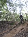
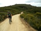
Berowra Heights - Wideview Road to Turner Road Loop
At a Glance
This is a Fun 7.4Km loop on FireTrail, Short Single Track and Sealed roads


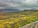
Mount Hay
At a Glance

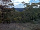
Butterbox Point
Flat Top
10min walk for some great views
Mount Hay
As beautiful as a mass of earth and life can get

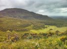
Flat Top and the open road....
Flat top is at around the halfway point where the bush opens up and the ride gets more enjoyable and scenic.
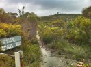
You can only get so close but you want to get closer and touch it as the view is amazing. Unfortunately NO BIKES past the end of Mt Hay Rd. If you want to get closer, bring a chain and lock plus some walking shoes.
Overall A decent ride with not to many steep hills. Trail was relatively smooth and the views are amazing.
Linden Ridge
At a Glance
Start Of Linden Ridge
Your Basic Fire Trail dropping 120m in elevation over 7kms with your pinch climbs here and there.
Fire Trail Behind Woodford Dam ridable?
Just wondering if the fire trail out behind the dam at the end of glossip road was accessible, legal and rideable?
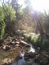
Nepean River
At a Glance
Nepean River View
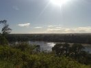
This is an amazing view, the only thing that ruins it is the quarry on the other side.
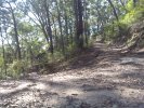
The Gate

At the end of Riverview Rd you will find this gate which is the start off the trail so to speak. The Pavement only runs to top of the hill. A key Note to remember is for the return trip. Allot off speed can be gained coming back down and the last thing you want to be doing here is a superman impersonation.
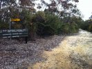
Fire Trail running parallel to the Nepean River from Emu Heights to Yellomundee Regional Park.
Not for Beginners

Fallen Tree on downhill at end of Winbourne Road Trail
Coming down Winbourne Rd Trail, there was some uphill climbs, but was mostly downhill runs with plenty of speed humps. I enjoyed this ride so much. Just the one fallen tree upset a great ride (only a little bit)
End of Winbourne Road Trail

Approaching the Dam from Winbourne Road.
Very fast and full of speed humps. Made for some good jumps.