You are here
AM
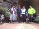
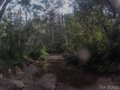
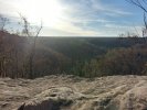
Cripple Creek
At a Glance

Creek Crossing Long Angle Rd
Rickard Fire Trail Lookout
Uncertain of any official name but its at the end of Rickard Trail.
Old Cripple Creek Trail

Cripple Creek Fire Trail
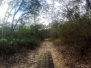
A network of fire trails that spans from Blaxland to Yellow Rock. Great for a short rides. Best for linking the Lower Blue Mountains to create some epic rides.
Dungog Common
At a Glance
Dungog Common is a MTB area next to the township of Dungog that comprises 650 acres and currently about 30 Km of MTB single track mostly blue and some black. I would call it a hard XC track or AM track. Ideal for Gravity Enduro.
We are working on new tracks and extensions all the time and you can expect another 10 Km within the next couple of months.

Loggers
Anybody able to show me this track or provide me a starting point?
Happy to discuss over PM.

Nice work Glenrock Trail Alliance
http://soulstream1.sptel.com.au/NBN_News//glenro...
[Mod. moved to Newcastle & Hunter]